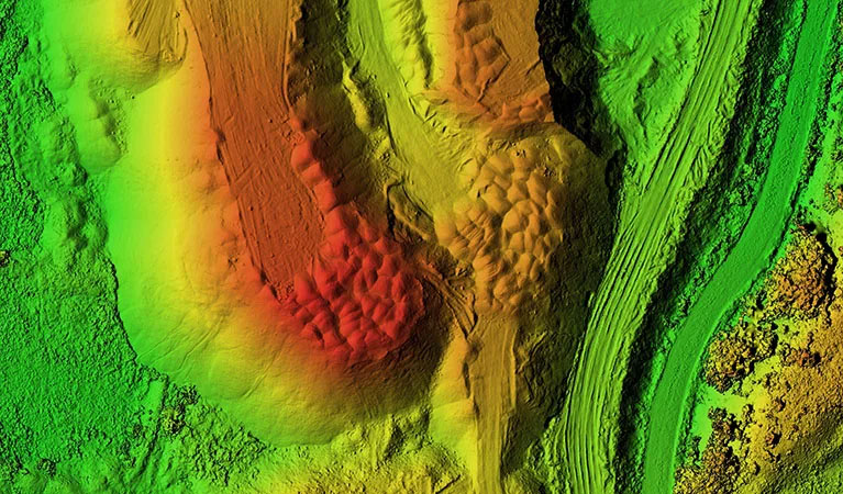
The Intelligence Necessary for High-Stakes Decision Making
As Vienna evolves into a pivotal hub for logistics and industrial growth within Dooly County, the tolerance for error in site data has vanished. For the civil engineers and land developers shaping the Coastal Plain, conventional ground-based surveying often falls short of the speed and comprehensive detail required by today’s aggressive project schedules. Vienna Ag Drones offers a revolutionary approach to site intelligence. We provide more than just "drone photos"; we deliver survey-grade geospatial data that acts as the primary source of truth for your most vital infrastructure projects.
Our methodology is designed to solve the logistical hurdles common to South Georgia: inaccurate estimates, safety liabilities on active sites, and the steep costs of traditional aerial mapping. Utilizing a fleet of DoD-approved, Blue UAS platforms outfitted with elite sensors, we can map thousands of acres and capture millions of precise coordinates in a single day. Whether you are managing a large-scale aggregate facility in Vienna or surveying a cross-county utility corridor, our data integrates directly into your existing CAD and GIS environments for immediate analysis.
The Security of Blue UAS
In an era of heightened digital scrutiny, protecting your site’s sensitive information is a non-negotiable requirement. All survey operations at Vienna Ag Drones utilize Blue UAS Certified systems, meaning they have undergone rigorous cybersecurity and supply chain auditing by the U.S. Department of Defense. For those managing critical infrastructure near Vienna—including energy grids and transit networks—this certification guarantees that your asset data remains secure and protected from the moment of capture to final delivery.
Volumetric Surveys: Absolute Inventory Control
For the industrial and resource sectors of Dooly County, precision in inventory management is the difference between profit and loss. Relying on manual "walk-up" measurements is not only time-consuming but places personnel at risk near steep highwalls and heavy machinery. We eliminate these hazards while dramatically increasing the accuracy of your measurements. Our 61MP full-frame sensors capture high-resolution imagery to generate dense 3D reconstructions of your entire inventory area.
By processing this data through PIX4Dmatic, the industry’s leading photogrammetry engine, we produce auditable cut/fill reports and stockpile volumes with centimeter-level precision. For Vienna-based project managers and accountants, this transforms monthly reconciliation into a stress-free, data-driven process. We provide a transparent, digital record of your materials that can be analyzed and shared across your entire team within 24 hours of flight.
LiDAR Surveying: Visualizing the Ground Through the Canopy
The Georgia Coastal Plain is defined by its extensive pine forests and dense hardwood bottoms, which frequently obscure the ground from traditional cameras. Engineering projects in Dooly County require an unfiltered view of the terrain hidden beneath this vegetation. This is where our LiDAR (Light Detection and Ranging) technology excels. We utilize the Riegl miniVUX-2UAV, a premier sensor engineered for the most demanding vertical accuracy requirements.
By emitting millions of laser pulses per second, our LiDAR system "sees" through even the thickest South Georgia canopy. These pulses reflect off the forest floor to create a high-density "bare earth" Digital Terrain Model (DTM). For developers in Vienna planning new commercial sites or engineers designing complex drainage systems in flat coastal terrain, this data is transformative. Our LiDAR surveys offer better than 1-inch absolute vertical accuracy, revealing the subtle topographic nuances that standard photogrammetry would miss.
Expansive Infrastructure & Multi-Fleet Operations
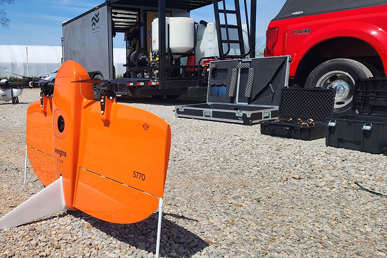
Scope is often the primary obstacle for regional development. Standard quadcopters lack the flight time to cover massive tracts of land, while manned aircraft are often cost-prohibitive for routine updates. We solve this by deploying the WingtraOne Gen II, a VTOL fixed-wing aircraft capable of mapping over 700 acres per flight—ten times the efficiency of a traditional drone. For Vienna’s largest industrial parks or expansive agricultural holdings, we can deploy multiple crews simultaneously to capture massive datasets in record time.
This parallel acquisition strategy allows us to map thousands of acres in a single day without compromising on detail. With integrated Post-Processed Kinematic (PPK) technology, every data point is geotagged with centimeter precision, drastically reducing the need for ground control points. This streamlines the operational footprint on your site and provides a cohesive, ready-to-use dataset for comprehensive land development planning.
3D Property Digital Twins & Site Modeling
Move beyond flat maps and imagine your project in a fully interactive, photorealistic 3D environment. Traditional blueprints can struggle to convey the true spatial context of a complex development. Vienna Ag Drones produces immersive 3D digital twins that allow Vienna stakeholders to visualize and measure their projects with unparalleled clarity.
By merging overhead and oblique perspectives, we generate high-textured 3D meshes and point clouds that serve as a living "as-built" record. This is an indispensable tool for monitoring construction milestones, conducting architectural light/shadow studies, and marketing premium commercial assets. For local developers, a digital twin provides a verifiable, time-stamped record of earthwork and structural progress, ensuring every phase of the project adheres to the original design intent.
Data Accuracy Specifications
Horizontal Accuracy
1.0 cm
PPK-Enhanced Precision
Vertical Accuracy
< 2.5 cm
LiDAR Terrain Accuracy
Ground Sampling Distance (GSD)
0.7 cm/px
61MP Full-Frame Imagery
Seamless Managed Workflow
Your dedicated Dooly County Project Manager directs the entire process, from initial scoping and flight planning to final processing in Pix4Dmatic. We deliver high-quality data in the specific formats your engineers require, including DXF, DWG, LAS, and GeoTIFF.
Request Technical Scoping